Collins Childrens World Map
Published: 2015
Add this book to your 'I want to read' list!
By clicking here you can add this book to your favourites list. If it is in your School Library it will show up on your account page in colour and you'll be able to download it from there. If it isn't in your school library it will still show up but in grey - that will tell us that maybe it is a book we should add to your school library, and will also remind you to read it if you find it somewhere else!
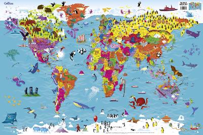
Colourful Illustrated Map of the World This highly illustrated pictorial map is designed to take children on a journey of discovery around the countries of the world. The mapping is clear, colourful and highly informative and shows countries and capital cities. Stunning illustrations are used to depict themes such as national emblems, customs, food, birds, animals, buildings and sports to help younger readers gain an understanding of peoples around the world. Dimensions 610 X 915 mm Illustrated by Steve Evans.
This book features in the following series: Collins, Collins Primary Atlases .
This book has been graded for interest at 4-8 years.
This book was published in 2015 by HarperCollins Publishers .
Collins UK has been publishing educational and informative books for almost 200 years.


